UX designer
1 week
1 UX Designer
Figma
Wireframing (mid-fi)
Prototyping (hi-fi)
not applicable
When resources are limited or you need quick, actionable insights, we will use guerrilla research.
To better understand the needs of Strava users, I conducted guerrilla research within my own academic environment. I reached out to my classmates, many of whom are athletes, to discuss their sports routines and experiences with fitness-tracking apps. Fortunately, I identified two users right in my class who provided valuable insights into their use of Strava.
Our discussions made it clear that these users were generally satisfied with the app, particularly because it allowed them to track and surpass their previous performance records across various activities like running, walking, and biking. This ability to view their progress seemed to boost their motivation significantly.
However, one user faced a recurring issue: despite his enthusiasm for running, he often ended up lost, especially in unfamiliar cities. This was a crucial pain point that needed addressing.
To solve this problem, I conceptualized a feature enhancement for Strava—a live GPS function that not only tracks but also suggests routes in real-time during the activity. This would ensure users can always find their way back to their starting point without compromising the spontaneity of choosing their path.
I created a user persona named Pedro to represent this segment of Strava’s user base.
Pedro is an active musician who enjoys daily runs but dislikes the uncertainty of not finding his way back. The proposed GPS feature would allow users like Pedro to select the desired length of their running route beforehand, ensuring they can explore without getting lost.
This enhancement would not only improve user satisfaction by addressing a specific user need but also align with Strava’s mission of motivating and supporting its users' athletic lifestyles.
The proposed live GPS function is designed to dynamically guide users through their activities by providing real-time route suggestions directly on a map interface. This feature is particularly beneficial for users who enjoy exploring new areas or those who tend to get lost while focusing on their exercise.
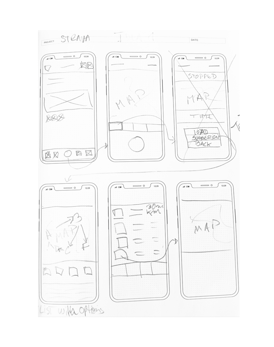
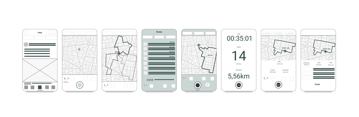
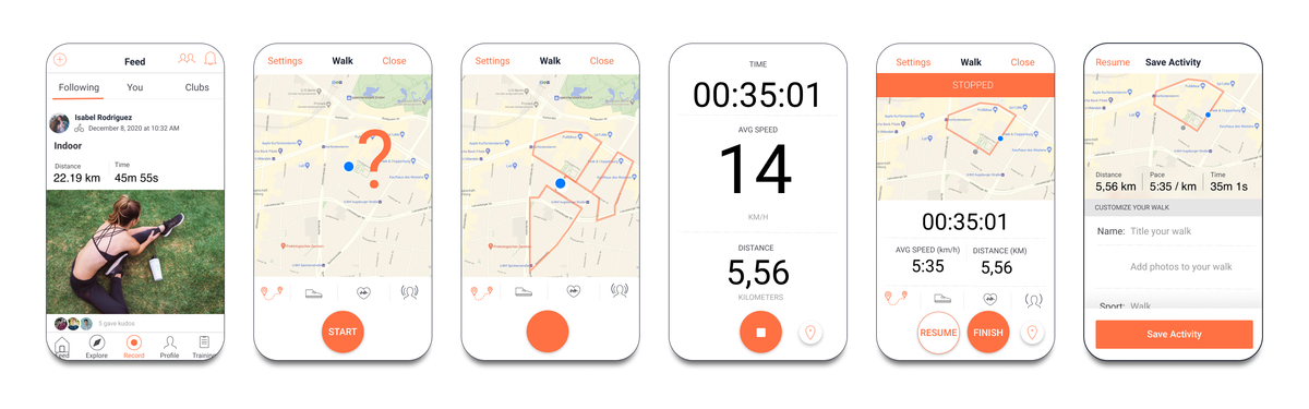
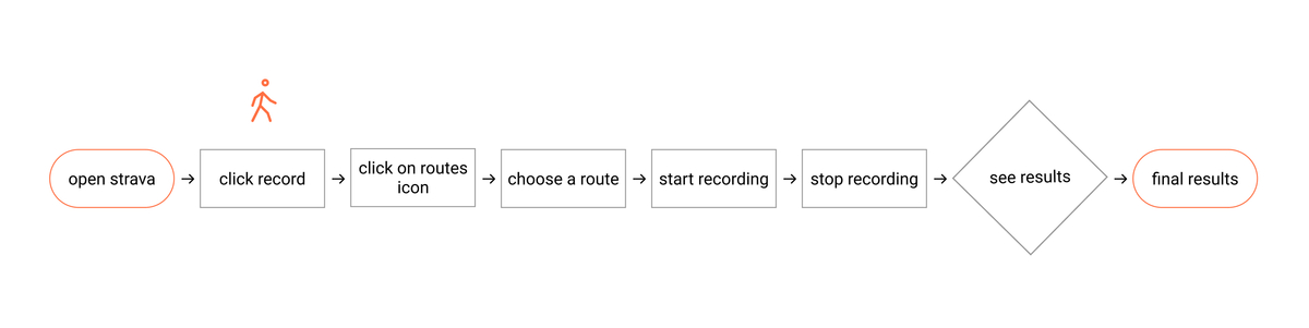
As the user engages in an activity, the GPS continuously updates their position on a map displayed on their device. Simultaneously, the system analyzes available routes and suggests optimal paths based on the user’s current location and predetermined preferences, such as route length or difficulty.
Users can start their activity with a basic idea of direction or choose a specific goal for distance. As they move, the map updates and suggests routes in real time, allowing users to make spontaneous decisions at forks or intersections without stopping to plan.
This feature would utilize the device’s built-in GPS to track location, combined with a sophisticated mapping service that offers various route options. Algorithms would calculate routes in real-time, considering factors like current location, user preferences, and possibly even current traffic conditions or environmental factors.
- Confidence in Navigation: Users can explore new areas without the fear of getting lost, as the app provides continual guidance back to their starting point or towards a defined endpoint.
- Customised Experience: The app tailors the experience to individual fitness goals and interests by allowing users to set preferences for route length and difficulty.
- Safety: With real-time route suggestions, users are less likely to end up in unsafe or undesirable areas, as the app can guide them along well-traveled paths.
- Battery Usage: Continuous GPS tracking can significantly drain battery life, which needs to be optimised.
- Data Usage: Depending on the implementation, the feature might require substantial data exchange to update the map and route suggestions, which could impact users with limited data plans.